Conjecture On Where That Plane Really Is
The New York Times has the article Lost Jet’s Path Seen as Altered via Computer.
The fact that the turn away from Beijing was programmed into the computer has reinforced the belief of investigators — first voiced by Malaysian officials — that the plane was deliberately diverted and that foul play was involved. It has also increased their focus on the plane’s captain and first officer.
This is all very interesting, but I have been waiting for someone to publish a large enough map for me to draw on.
Whoever publishes one of these maps always shows you two red arcs where the plane could have been when it lasted contacted a satellite.
I was thinking that one could be a lot more precise about where the plane could be if you drew a circle of how far it could have flown between the last time it was sighted by radar and the time it contacted the satellite.
I have drawn that circle.
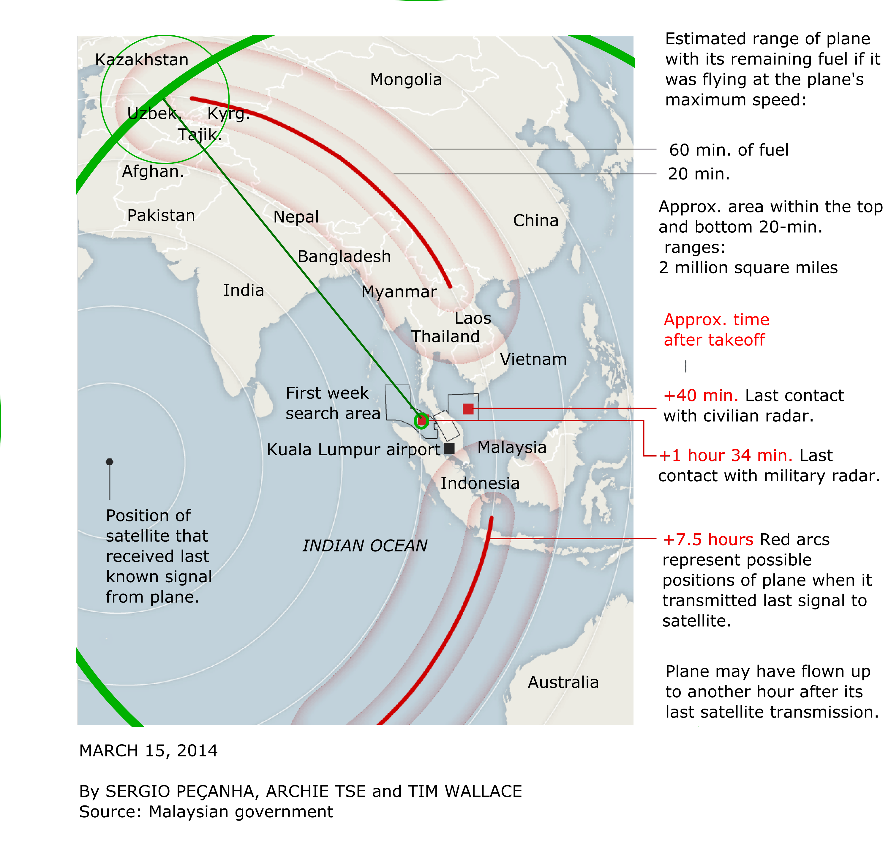
The thick green arcs are from the circle I drew of how far the plane could have flown at full speed in the 6.5 hours between its last radar sighting and the time it last contacted the satellite. From that point, I drew an thin green circle for where it could have flown in the hour after the contact with the satellite. Unless the plane slowed down from its full speed or its ground speed was slower or faster than its air speed due to winds, it would not have intersected the red arcs anyplace else other than where I estimated.
So I assume that the agencies that are searching for the plane have a heck of a better idea where it is than what they have said in public. Of course, there are lots of assumptions in the arc that I drew, so there is no guarantee that the plane is located within the small green circle, but I bet it is likely.
The plane most likely would have flown over Afghanistan. Are we expected to believe that our military operation in Afghanistan would not have noticed?
By my estimation the plane is probably in Kazakhstan, Uzbekistan, Kurgyzstan, or Tajikistan. I wonder if Russia still has much influence in these countries?
I have added a green line to show the flight path from the last known radar contact (before Thailand reported that they have a radar contact) to the intersection. That helps to visualize what countries the plane might have flown over, and how likely the country would have had the radar to detect the overflight.
Also bear in mind that if the plane had not been flying at full speed, drawing concentric circles inside the big one I drew would give you the intersection with the satellite arc for these slower speeds. The radius from that point of intersection to where it could have flown in one hour at the slower speed would also be smaller.
Although, also consider that the last contact with military radar at the 1 hour and 34 minute mark must not have been a single blip. There was probably a flight path detected. Is it a coincidence that the line I drew to the intersection of the satellite detection is right through the section of ocean to which the search was shifted in the first week?